|
The Writer's Home Range
The Lehigh Trail
by
For years I had been vaguely aware that Terry and I were coming across abandoned railbeds pretty much everywhere we went in Western New York. In the case of the Lehigh Valley Railroad, for example, although the mainline appeared in my DeLorme atlas—as an east-west string of red dashes, well south of Rochester—the only portion I had personally examined lay along the southern edge of the Genesee Country Museum. But publication of The
Official Rails-to-Trails Conservancy Guidebook1 in 2002 helped me appreciate more fully the extensive access to the land that trails based on railbeds offer. And occasional newspaper reports made it clear that ambitious plans for developing the Lehigh locally were indeed headed toward implementation. Links Make Happy Trails [and] Riders, proclaimed the headline for an article in the 22 July 2002 issue of the Democrat
and Chronicle: Multi-million Dollar Projects Will Connect, Expand Area Paths.2
In June 2003, I began the process of orienting myself more systematically
to the Lehigh mainline by hiking to it from Route 251, along the Genesee Valley
Greenway (which itself follows the abandoned bed of the Pennsylvania Railroad).
Immediately eastward of where the Pennsylvania passed beneath the Lehigh was
the steel support structure that once carried the Lehigh over the Genesee.
In the absence of an actual bridge, I couldnt
cross. But I felt that I had found an important corner piece to a huge jigsaw
puzzle.
A month later, Terry and I tried hiking to the structure from the other direction. We parked where the railbed crosses East River Road and headed west. For a ways, the railbed was filled with mound after mound of coal cinders—material that Kodak had contributed toward the upcoming rails-to-trails project. Also along the way, we traversed the bridge over the active Erie line (now operated by a shortline railroad—the Livonia, Avon & Lakeville, or LAL):
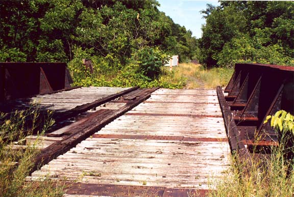
As a double-track railbed, the Lehigh cut a broad swath through the countryside—though not nearly as broad as an interstate highway. That difference reminded me of how Leopold viewed railroads in A
Sand County Almanac. Getting up too early, he noted in his essay on morning risers, is a vice habitual in horned owls, stars, geese, and freight trains.3 Although trains were the only technological phenomena on his list, he viewed them favorably:
The freight, I admit, is hardly reticent about his own importance, yet even
he has a kind of modesty: his eye is single to his own noisy business, and
he never comes roaring into somebody elses camp. I feel a deep security
in this single-mindedness of freight trains.4
Another favorable view appeared in his essay Great Possessions—though for a different reason:
The outstanding conservator of the prairie flora, ironically enough, knows
little and cares less about such frivolities: it is the railroad, with its
fenced right-of-way. . . . Within these linear reservations, oblivious of
cinders, soot, and annual cleaning-up fires, the prairie flora still splashes
its calendar of colors . . . .5
By contrast, roads for automobiles tend to obliterate the original habitats through which they pass. Thus Leopold noted in Illinois Bus Ride:
I am sitting in a 60-mile-an-hour bus sailing over a highway originally laid out for horse and buggy. The ribbon of concrete has been widened and widened until the field fences threaten to topple into the road cuts.6
And in an essay on a wilderness area that he had personally experienced in the early twentieth century, his voice took on a tone of regret:
When I first lived in Arizona . . . White Mountain was a horsemans world.
Except along a few main routes, it was too rough for wagons. There were no
cars. . . .
Henry Fords revolution has of course abolished all this.7
Although these thoughts first came to me while exploring the Lehigh mainline, I had a hard time appreciating the full effect of Leopolds insight—because the broad right-of-way felt more like a road than a trail. In fact, so accessible was the abandoned mainline that occasional motorists sought to emulate the TV commercials and demonstrate the off-road capabilities of their vehicles—leaving us little choice but to step aside and wait for the dust to settle.
But the single-track branch that once tied the mainline at Rochester Junction to downtown Rochester was different. Being narrower than the mainline—and more varied in its features—its scale was better suited for hiking. So thats where I actually experienced the single-mindedness of railbeds, as they make their bee-lines across the landscape, inadvertently preserving the natural habitat in the process.
As breaks from our busy schedules, Terry and I managed to hike (in various segments) the whole length of the branch line, between Rochester Junction and the onset of the active rail line (also operated by the LAL) at Lehigh Station Road. Meanwhile, however, I began hearing mental warning bells. The mainline and the stretch of the Rochester branch that we had hiked were outside my Home Range. But north of Lehigh Station Road, the active line runs through the landscape I traverse everyday—and gradually I realized I couldnt picture its route clearly.
From my visits to the U of R campus, I knew that two rail lines—the Lehigh and the Erie—once proceeded side-by-side. For example, they crossed Elmwood Avenue on a pair of adjacent bridges that still stand. I also knew that north of the U of R campus, the Erie crossed the river, while the Lehigh kept to the eastern bank. Thus the two downtown stations had been located opposite one another, at either end of the Court Street bridge. Although the Erie station was torn down in the 1940s, the Lehigh station still stands—and houses the Dinosaur Bar-B-Que restaurant.
Closer to home, on my usual route to the RIT campus I cross the LAL/Lehigh on Calkins, between the intersections with Hylan Drive (to the north) and Middle Road (to the south), and I cross the LAL/Erie on Bailey, just after the intersection with Beckwith Road (to the south) and just before Bailey climbs a slight hill toward the intersection with John Street. But after years of driving east and west on Jefferson Road, I had never thought to ask why there is only one rail crossing.
That was one aspect of the alert I began hearing—faintly at first, and then stronger and stronger—as Terry and I started our explorations: two abandoned railbeds from the U of R north and two active rail lines on my route between home and RIT, but only one crossing at Jefferson. I must be a funny fellow, but things like that make me uneasy. Already in these essays Ive written about one example, namely, the question of where the water from our yard drains. Here was another. That kind of alienation from the land—when I finally become aware of it—nags away at me.
During the Spring of 2003, I began working out the routes of the Lehigh and the Erie in the vicinity of RIT. One day, on my way home, instead of immediately taking John to Bailey, I drove across John and explored the eastern edge of RITs Colony Manor Apartments, but I saw no way of gaining access to the Erie tracks. On another occasion I explored the industrial area just south of the Lehigh tracks, west of where they cross West Henrietta. Commerce Drive indeed went as far as the Erie tracks—and across the way I could see the apartments. But I was too far south to see how the Erie and Lehigh joined.
Finally I tried Silverole Road, south off Jefferson, near the Ryder place
(where I had rented the van I used to bring Grandmas papers to my apartment).
Silverole didnt
go far before dead-ending. But only a few steps were needed to give me a view
of the active Erie line headed south:
For a short distance north I traced the abandoned railbed (still strewn with old wooden ties, as the photo shows) and then lost it in the dirt fill. More to the point, however, a newly constructed railbed arced eastward, toward the Lehigh—which is why Silverole had dead-ended—and a quick drive to the western end of Southtown Plaza confirmed the link.
After that, I proposed an outing to Terry, to show her the picture I was putting together. But along with the drive, there was also something else I wanted to try—because there was another aspect to the alert Id been hearing.
The buildings on the RIT campus each have names and numbers. My office, for
example, is located in the George Eastman Building, Building 1, and I get my
mail in
the Liberal Arts Building, Building 6. With that in mind, when some of the
new faculty began meeting informally at a nearby restaurant, in the late afternoon
once a week, they gave it a nickname. Officially its MacGregors Grill and
Tap Room, but my colleagues took to calling it Building
M.
Building M sits on the wedge of land between Jefferson and Brighton-Henrietta Townline Road. At the western tip of the wedge is the U-Haul place—where I had returned the truck I used when I moved here from Baltimore. During my first decade in Rochester, the most direct route from my apartment to campus was along Brighton-Henrietta Townline Road—so daily Id pass the back of MacGregors (actually, its predecessor, Red Creek Inn).
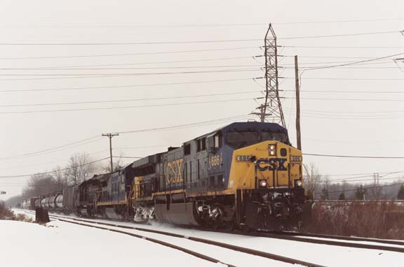
Just before Brighton-Henrietta Townline Road intersects Jefferson (across from John), it crosses a very active east-west rail line, and occasionally Id have to stop to allow fast-moving freight trains to pass. In the different names of that line can be read much of the organizational history of American railroads. Currently CSX, it had earlier been (in reverse chronological order) Conrail, Penn-Central, the New York Central, and—earliest of all—the New York, West Shore & Buffalo Railroad, or the West Shore for short.
The problem that now came to me was that in all the time I had been driving along Brighton-Henrietta Townline Road, I had never bothered to notice that there were crossings for neither the Erie nor the Lehigh. So as I got caught up in the project of exploring their routes, I deliberately scanned the roadside to the north. Sure enough: in immediate succession, hardly more than a hundred feet apart, were two abandoned railbeds. How alienated from the land had I been, not to have noticed them before—despite having driven past them hundreds of times!
By then I knew from my research that the wedge of land had once been the site of three rail lines—the Erie, the Lehigh, and the West Shore—all crossing each other at grade level. So as part of the outing with Terry, we began sizing up, on foot, the remains of Mortimer Junction:
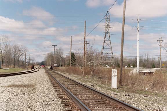
The photograph above was taken looking west, from about where the Erie once
crossed. The West Shore is the set of tracks through the center right, and
the white marker gives the distance from New York City. The set of tracks coming
in from the left is the relocated Lehigh—now used by the LAL—which
no longer crosses the West Shore but instead heads west, in parallel with it.
On the other side of the river are sidings—known as Genesee Junction—which
gives the LAL access to both the CSX and the Norfolk & Southern (via the Rochester & Southern—formerly
the Baltimore & Ohio).
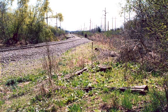
On our walk, north from Mortimer Junction, Terry and I first tried the abandoned Lehigh railbed. But its ballast tended to be too large for comfort. By contrast, the small, dark, earthy cinders of the Erie were much easier on our feet.
Leopold may have been impressed by how railroad rights-of-way inadvertently preserve local ecosystems. But what impressed me about the Erie-Lehigh corridor was how the railbeds were giving us proximity to the infrastructure thats so essential to our daily living.
As we headed north, I pointed out to Terry the RG&E electric power station—brick buildings that dated back to the turn of the century, when the Erie established (between Rochester and Mount Morris) one of the nations first electrified lines to use single-phase AC. After that, we examined the rusted metal electrical power-line tower (just east of the Lehigh railbed, in the upper center of the photo):
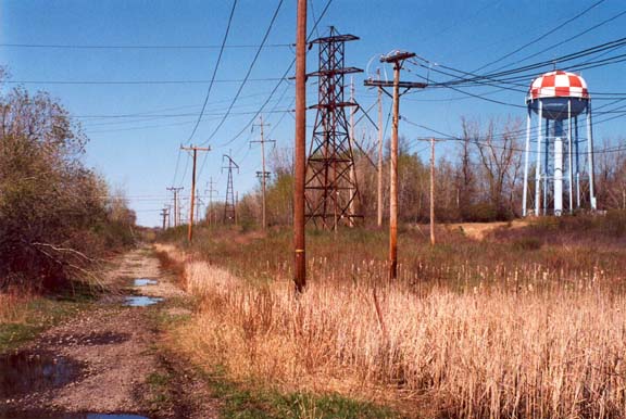
Terry was drawn to the old ceramic insulators we found under the tower—presumably left on the ground after being replaced—while I located the Carnegie markings cast into the steel members. We also walked up to the fenced-in base of the water tower. Its red-and-white checkerboard dome had long been a familiar, though distant landmark in my daily travels, and now I could see that it also functioned as a cellular telephone tower.
As a result of these various outings, my level of discomfort was definitely
declining. But the warning bells hadnt
stopped completely. There continued to be things about the railbed routes that
still needed exploring.
During the Summer of 2005, I noticed the new signs that had gone up, to signify the newly-developed Lehigh Valley Trail. Because the line between Lehigh Station Road and Mortimer Junction remains active—and posted—the connecting trail consists of what Terry calls road work.
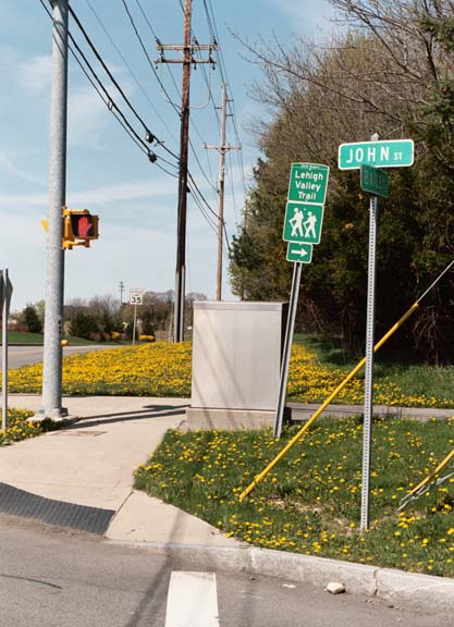
It was the roadwork signage I had noticed—at various points along Calkins to West Henrietta, to Bailey, to John, and finally to Brighton-Henrietta Townline Road—so that the trail coincides with the sidewalk along RITs eastern boundary.
During that same time interval, the railbed had been resurfaced and entrance gates put up. Oddly (to me, at least), the trail north of Brighton-Henrietta Townline Road begins on the Erie railbed. Then—after a hundred yards or so—it jogs over to the Lehigh (a pattern thats repeated north of Crittenden Road).
Even with all that worked out, however, there remained features of Mortimer Junction I hadnt yet located. As indicated on older maps, the junction had once included wyes—short rail arcs that tied the Erie and Lehigh to the West Shore. Having never noticed them before, on another drive I repeated the exercise of deliberately scanning the area north of Brighton-Henrietta Townline Road. Sure enough, with no effort at all, I could see an arcing embankment—which, on a subsequent hike, I confirmed as indeed being a wye remnant.
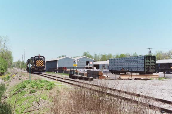
Because West Shore is such an active line, I thought I should try taking a current train photo. Already I had lucked into an opportunity to photograph a pair of LAL locomotives, returning from a delivery to the Matthews and Fields lumber yard, on Lehigh Station Road:
So in the parking lot behnd MacGregors, I deliberately waited until an east-bound CSX train raced through:
But full resolution of my uneasiness required something else. Along with its buildings, roads, and railbeds, Mortimer Junction also includes a stream. Here, however, Red Creek carries only the waters of the Middle and East Branches. Thus the question arose: where does the West Branch—the stream that skirts the high ground of the RIT campus—flow into Red Creek?
On a crisp fall day in October 2005, I returned to the stretch of the Lehigh Valley Trail just north of Crittenden Road. Terry and I had already reconnoitered all the way to East River Road. But now I focused on what the water was doing. After about a hundred feet, the railbed crossed a streamlet. Immediately after that was an undeveloped foot trail to the left—which I took—and by bearing left whenever I could, I soon found myself following Red Creeks eastern bank.
I hadnt gone far before a confluence came into view, on the western side.
The drama of the place wasnt high. Both streams bore fallen leaves on their
surfaces and reflected the overarching trees. And if I looked closely, I could
see a slight current in the mainstream.
In that view, the mental alarms finally stopped sounding. Down the mainstream came the water from home, and across the way came the water from campus—so I was seeing for myself the joining of the waters, from the two places where I spend the bulk of my time.
Im aware that much about my Home Range still needs to be researched. I
also know that surprises likely remain. But no longer do I feel uncomfortably
alienated. After years of writing about places elsewhere—and enjoying
it—Ive discovered that its
also satisfying to write about my immediate surroundings. In the future I look
forward to doing more of both.
Notes
1 Craig Della Penna and Tom Sexton, The Official Rails-to-Trails Conservancy
Guidebook: The Definitive Regional Guide to Multi-use Trails (Guilford, Conn.: Globe Pequot Press, 2002).
2 James Goodman, pp. 1A and 4A.
3 Aldo Leopold, A Sand County Almanac and Sketches Here and There (New York: Oxford University Press, 1949), p. 59 (in the essay Too Early).
4 Ibid., p. 61.
5 Ibid., p. 48.
6 Ibid., p. 117.
7 Ibid., pp. 122-123 (in the essay On Top).
|