|
Mendon — The Early Years
The Expedition of the Marquis de Denonville
and Related Matters
by
Over three hundred years ago, much of what is now Western New York State was the scene of contention between France and England. Both nations claimed sovereignty and were determined to possess the region. The claim of the French was based on the right of discovery; that of the English upon royal charters disposing of all the country south of the Great Lakes; and also, as far as the right to New York State was concerned, upon conquest from the Dutch.
Barring the way was the powerful Seneca Nation of native red men who loved
the region fiercely and fought for it with grim vigor. French explorers, coming
from the St. Lawrence River area, had tried to induce the Senecas to give their
allegiance to King Louis XIV and almost succeeded. The prize that each warring
European nation wished to capture was the fur trade as well as wanting the
land as its sovereign territory.
French priests, most of them of the Jesuit order, established missions at Seneca sites in the present towns of
Victor, Mendon, lima, and East Bloomfield. Here chapel bells rang and the rites of the Catholic Church were performed.
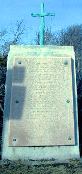
In the Town of Mendon, where the No. 6 Road, leading west from the Village of Honeoye Falls, crosses the Rush-Lima
Road, stands a large monument, erected in 1938 by the Order of the Alhambra in honor of the French Missionaries.
The inscriptions on the monument read as follows:
|
|
1668-1709
NEAR THIS SITE CATHOLIC MISSIONARIES ERECTED HOUSES OF WORSHIP IN THE WESTERNMOST
SENECA VILLAGES OF THE IROQUOIS CONFEDERACY. THE CHAPEL OF LA CONCEPTION WAS
BUILT IN 1668 AT TOTIAKTON (NEAR ROCHESTER JUNCTION) ST JEAN CHAPEL WAS ERECTED
IN 1669 AT GANDACHIRAGOU ON THE LIMA ROAD.
THE RESIDENT MISSIONARIES WERE FR.
JAMES FREMIN, SJ. (1668-1670), FR. JULIEN GARNIER, SJ. (1669-1693), FR. PETER
RAFFEIX, SJ. (1672-1680)
NOTABLE VISITORS WERE FR. RENE GALINEE, S.S. (1669),
FR. SIEUR DE LA SALLE (1669),
FR. JAMES BRUYAS, S.J. (1673),
WENTWORTH GREENHALG (1677), FR. LOUIS HENNEPIN, RECOLLET (1679)
AFTER THE DESTRUCTION
OF TOTIAKTON BY DENONVILLE'S ARMY IN 1687, A NEW VILLAGE WAS FOUNDED ON NEARBY
SPRING BROOK.
THE MISSIONARIES WERE FR. JULIEN GARNIER, S.J. (1701-1703), FR.
VAILLANI DJ GUISLIS, S.J. (1702-1707), FR. JAMES D. HEU, SJ. (1707-1709)
WHEN
POLITICAL CIRCUMSTANCES COMPELLED THE FINAL WITHDRAWAL OF FRENCH MISSIONARIES
FROM THE REGION THE ADMINISTRATIONS OF RELIGION TO THE CHRISTIAN INDIANS WERE
CONTINUED THROUGH CONTACTS WITH CANADIAN MISSIONS WHERE MANY DESCENDANTS OF
THE SENECAS STILL PERSEVERED IN THE FAITH BROUGHT TO THIS LOCALITY BY THE ABOVE
MEN OF GOD.
|
In the summer of 1687 Jacques Rene de Bresay, the Marquis de Denonville, Governor of New France (Canada), led an expedition of 1600 French soldiers, 400 Canadian colonials, and 983 Native American allies into western New York State. The purpose of the expedition was to punish the Senecas, the foremost nation of the Iroquois Indian Confederacy, for their English connection and their interference in the lucrative French fur trade.
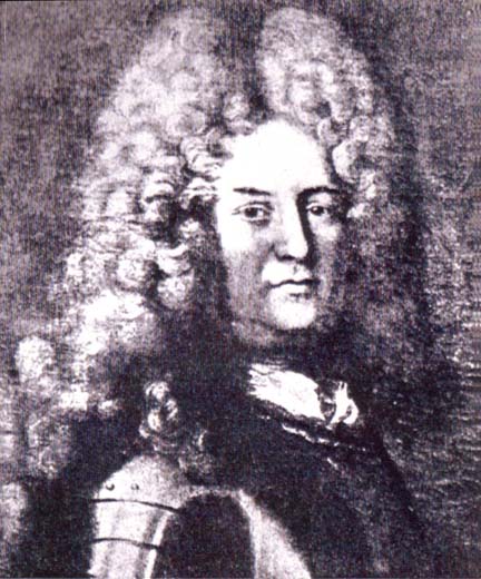
The Marquis de Denonville as pictured in Volume IV of the
Publication Fund Series of the Rochester Historical Society
Traveling by boat on the St. Lawrence River and Lake Ontario, the French
army arrived at Sodus Bay on July 8th 1687. By July llth Denonville and his
men reached the outlet of Irondequoit Bay and on July 12th constructed a temporary
stockade in the area that is today known as Seabreeze. Denonville's primary
goal was to destroy the two main Seneca villages, Gannagaro (now Ganondagan)
and Tokiaton. On July 13th his army reached Gannagaro, located on what is now
the Boughton Hill Road in the Town of Victor. After destroying the crops planted
by the Senecas, and burning their huge granary, the army marched eleven miles
on July 19th to the second village, Totiakton, situated on the fertile plain
on what is today appropriately called Plains Road in the Town of Mendon.
"Totiakton", is the Indian name meaning "In the bend of the stream" as Honeoye
Creek borders the former site of the village on the north and on the east.
By July 23rd Denonville's army had completed the burning of the Indian crops
and the destruction of over a hundred of their long houses.
Route of Denonville's 1687 expedition against the Iroquois: (1)
SodusBay—July 8, (2) Irondequoit Bay— July
11, 12, (A) Site of camp—July 12, (3)
Victor Sector (Boughton Hill)—July 13-19, (4) Totiakton
Sector—July 19-23, (5) Mendon Ponds—July 23-24.
Source: Rochester Historical Society.
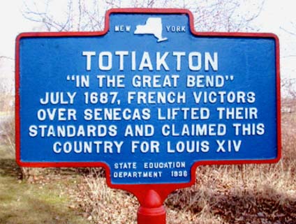
New York State Historical Marker placed at the Totiakton site in 1936.
Photo by the author.
* * * *
Abner Sheldon arrived in Mendon from Deerfield, Massachusetts in 1801 and two years later purchased the 170 acres of land that earlier had been the site of the Seneca village of Totiakton. Mr. Sheldon discovered on his farm the ruins of a palisade enclosure, covering about one half an acre, made of posts twelve feet long set four feet into the ground. Graveyards, scattered over the plain, yielded many relics, such as guns, knives, scissors, and even a jews-harp. The presence of these articles in the graves was based on the belief that food and implements would be necessary to the welfare of the departed soul on its journey beyond the grave.
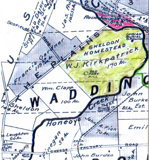
1902 Plat Map of Mendon showing the Sheldon-Kirkpatrick farm, the former site
of the
Seneca village of Totiakton. The Rochester Junction station of the Lehigh
Valley
Railroad shown in red to the north of the site. (Author's collection)
Upon the death in May 1898 of Abner Sheldon's grandson, Judson F. Sheldon, ownership of the farm passed to Judson's daughter Antoinette and her husband, William J. Kirkpatrick, a wealthy Rochester businessman, who were married on September 23, 1884. The couple lived in the city during the winter and spent the summer months at the Sheldon farm. Each day William commuted to his office in downtown Rochester from the nearby Rochester Junction station of the Lehigh Valley Railroad.
(Author's Note: A little over two hundred years after Totiakton was destroyed
by the French army, the Lehigh Valley Railroad built a station, known as Rochester
Junction, in the deep valley adjoining the former Seneca Indian site. For information
about Rochester Junction, see the author's article on this subject in the Summer
2006 issue of the Crooked lake Review.)
William Kirkpatrick inherited the Sheldon farm upon the death of his wife on March 15, 1918. Five years later he sold the property to Louis Desmann who worked the farm until his death on October 6, 1942. Louis's son, Dean Desmann, continued the farming operations until September 1979 when, after the death of his mother, in order to settle her estate, the farm was sold to a real estate developer. Large new homes have been built on a portion of the original Totiakton site that borders Plains Road. Thirty nine acres of site have been donated to the Mendon Foundation, a not-for-profit land trust, and will be forever protected from development under the stewardship of that organization.
* * * *
The Chevalier de Baugy, a young French nobleman, who served as aide-decamp to the Marquis de Denonville during the expedition, kept a journal of his experiences during the summer of 1687. In that journal he states that on the evening of July 23rd upon the return march from Totiakton to the stockade at Irondequoit Bay, the army traveled "two good leagues" to where the soldiers camped overnight by "three exceeding pretty little lakes". This is the first reference in recorded history to the three principal ponds located in what today we call Mendon Ponds Park. The route that the army followed was a well used Indian trail that in later years became Clover Street and now forms the western boundary of the Park.
* * * *
The acquisition of this land for use as a county park was first advocated by Herman L. Fairchild, Professor of Geology at the University of Rochester. In August 1926 he said: "The Mendon Kames area, with its unusual display of glacial topography and phenomena; its group of lakes so rare in this region; its peculiar botanical interests; its elevation value from the surrounding country; its Indian trails and campsites; and its higher educational value in nature study should he preserved inviolate; either as a State or County Park."
On June 1st 1928 the Monroe County Parks Commission recommended that the Board of Supervisors take options on 1400 acres of land surrounding the three ponds with a purchase price of $185,000. Following the approval by the Supervisors, work was started several months later with the widening and improvement of the three dirt roads that gave access to the one mile wide, two mile long tract. The Park Commissioners stated that the cleared farm land would be reforested, the ponds stocked with game fish, trails laid out through the hills for the benefit of hikers and horseback riders and that shelters and fireplaces would be built for picnickers and campers.
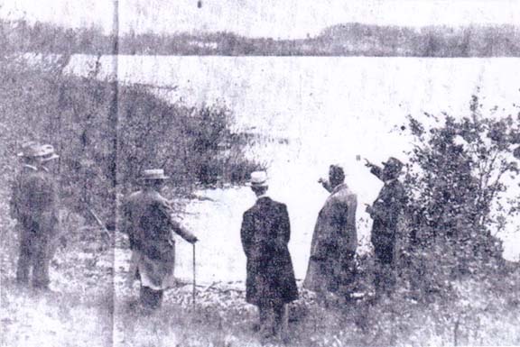
Monroe County Park Commissioners viewing 100 Acre Pond at the time of the
initial
purchase of land for Mendon Ponds Park. (Photo June 1, 1928, Rochester
Times Union.)
In a speech delivered June 21st, 1930 Professor Fairchild stated in part: "The features in Mendon Ponds Park are a striking example of the most dramatic event in Western New York since this part of the world was lifted out of the ocean. That event was burial under a deep sea cap. This group of gravel hills and deep basins forms the most interesting topography in Monroe County."
"It stands up as an isolated mass, some two mile square, lifted high above the surrounding plain. It is the finest example of the glacial forms, called kame, kettle, and esker. And the enclosed ponds are the largest of this kind in Western New York."
"It is fortunate for the scientific education and nature study to have the area permanently preserved as a public park. With its scenic value and its geologic interest, it is deserving of more attention and scientific appreciation than it is ever likely to receive."
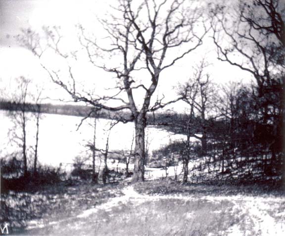
1930 Photo of 100 Acre Pond. (Courtesy of Honeoye Falls/Mendon Historical
Society)
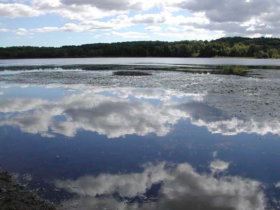
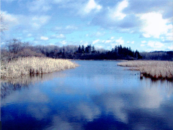
2007 Photo of 100 Acre Pond. Taken from Hopkins Point on a
late summer day
with clouds reflecting on the water. ( Photo by author)
* * * * *
By 1961 further purchases of land, as the park expanded in a southward direction,
brought the total acreage to 1698 acres. Major acquisitions during the 1960's
at a cost of $1,131,700, resulted in a total of 2363 acres by the end of that
decade. With subsequent purchases the amount of land in Mendon Ponds Park
now exceeds 2500 acres. Today the Park serves as a recreational area for thousands
of people who use its facilities every year. In the summer numerous picnics
are held in the shelters that provide protection from the weather on inclement
days. In the winter cross country skiers can be found enjoying the snow on
the hilly trails and ice fishermen cast their lines on 100 acre pond. Year
around hikers and horseback riders from nearby homes and stables travel their
designated trails.
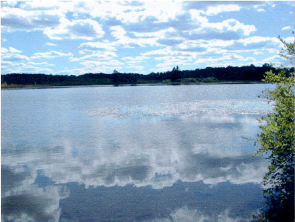
2007 Photo of Quaker Pond. Taken from the bridge that spans the outlet
of the
Pond into Irondequoit Creek. (Photo by author)
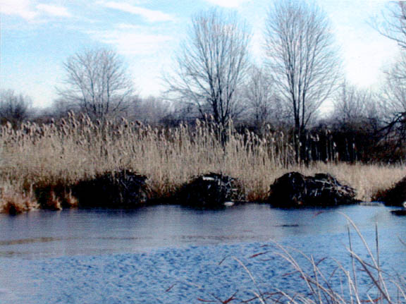
Beaver lodges located at the point where the water from Quaker Pond enters
Irondequoit Creek.
The early saw and grist mills in Mendon Center were powered
by this creek. (Photo by author)
2007 Photo of Deep Pond. Taken on a September afternoon from the hiking
trail
on the west bank of the Pond. (Photo by author)
Map of glacial geology in Mendon Ponds Park. Illustrated are
the "three
exceedingly little lakes"
described in Chevalier de Baugy's journal of Denonville's
1687 expedition into Western New York.
(Courtesy of Monroe County Parks Department)
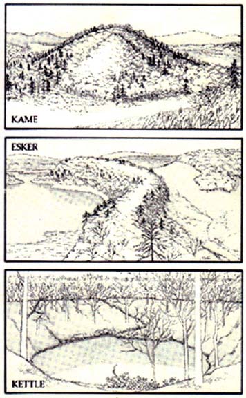
Illustrations of geological formations in Mendon Ponds Park.
(Courtesy of Monroe County Parks Department)
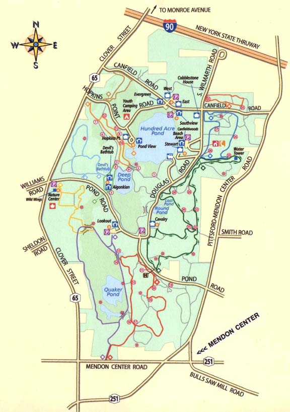
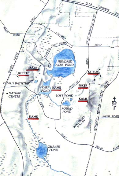
Map showing current (2007) configuration of Mendon Ponds Park.
(Courtesy of Monroe County Parks Department)
Our house is located a short distance from the Mendon Center Road entrance to the Park and, in our younger years, my wife and I used to ride our horses on the bridle trails. Today, in our senior years, we still enjoy a leisurely hike in the Park and never tire of looking at the beautiful scenery and observing the abundant wildlife. Among our favorite hiking trails are the Bird Song and Swamp Trails that form a two mile loop from the Park's Nature Center. These trails are reserved exclusively for hiking and on them one should come prepared with a supply of sunflower seeds to feed the chickadees who are waiting to land on your hand in order to get a treat.
Another trail that we frequently walk is the old Indian path located on top of an esker that begins at Canfield Road in the Park and runs south to the Devil's Bathtub, a kettle hole, formed by the Wisconsin ice sheet, a glacier that moved through the area over 12,000 years ago. The estimated depth of the Bathtub is forty six feet and, while it looks like a typical body of water, it has no intake or outlet. Snakes, frogs, and other wildlife make their homes around the perimeter which is lined with oak and maple trees. Their colorful red and yellow foliage reflects on the water on sunny autumn days.
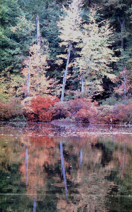
Fall foliage reflecting on Devil's Bathtub, a kettle hole in
Mendon Ponds Park.
(Photo November 16, 2005 Rochester Democrat & Chronicle.)
Joshua Lillie, the pioneer settler in the Mendon Ponds Park area arrived in 1811 from New England and cleared land for his farm near the intersection of Canfield and Wilmarth Roads, that was included in the initial purchase for the Park. His burial site is marked by a grave stone placed by his descendants some years ago.
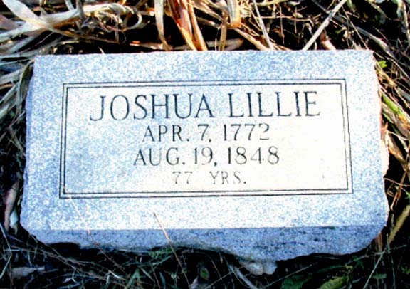
Grave Stone of Joshua Lillie, an early settler on land that
is now part of Mendon Ponds Park. (Photo by author)
* * * *
The Honeoye Falls/Mendon Historical Society has in its collection fifty glass plates showing scenes in the Park in 1930, two years after Monroe County acquired the original acreage for the Park. Of special interest are the photographs of the early farmhouses and barns that have been demolished or moved to sites outside the Park Fortunately, one of these has been preserved, the Stewart-Canfield house, built of cobblestones by Jeremiah Stewart circa 1835. In his book on cobblestone masonry, Carl Schmidt states that the house has the characteristics of the early period of cobblestones found in the southern part of Monroe County which he calls the "cradle" of this type of architecture, 1825-1835.
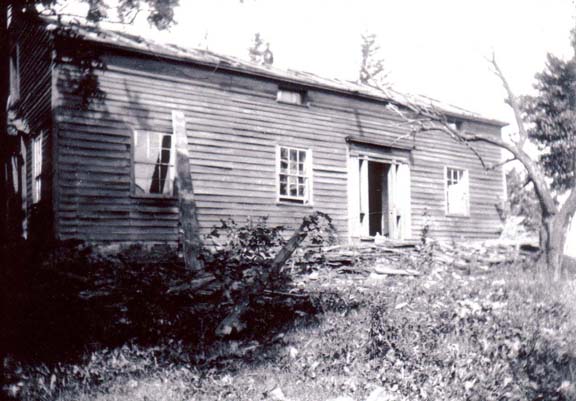
1930 photo of an early house demolished following the purchase
of land for Mendon Ponds Park.
(Courtesy of the Honeoye Falls/Mendon Historical
Society)
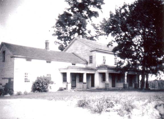
1930 photo of an early house that was moved from Mendon Ponds
Park to the Town of Henrietta.
(Courtesy of the Honeoye Falls/Mendon Historical
Society)
Jeremiah Stewart arrived in Mendon from Dutchess County, New York State in 1833. He was joined in 1834 by his wife Helen and seven year old Richard Canfield, also from Dutchess County. The farm, including the cobblestone house, passed to Richard Canfield. It was his son, Stewart Canfield, who sold the 131 acre farm in 1928 to the Monroe County Parks Commission.
For many years the Stewart-Canfield house was used as a residence for the superintendent of Mendon Ponds Park. More recently it served as a home for the caretaker of the Park's Nature Center. Totally renovated, today it is available on a reservation and fee basis for public events, such as wedding receptions and family gatherings
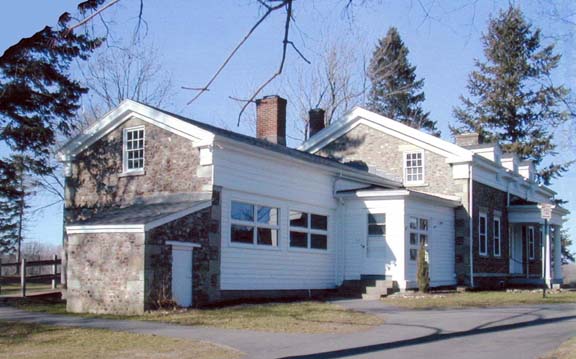
The circa 1835 cobblestone, built by Jeremiah Stewart, still
stands
in Mendon Ponds Park. (Photo by author)
* * * *
The 160 acre Garland farm, located at the intersection of Clover Street and Pond Road, was also included in the early purchases for Mendon Ponds Park. Daniel Quinby, who arrived in Mendon from Westchester County in 1830, was the first farmer to clear the land. In 1875 the farm was purchased by William Garland who had worked for Daniel Quinby as a hired man in 1840. In the spring of 1859, while living on a farm that he owned in the Town of Pittsford, William Garland purchased from the Wood, Taber, & Morris Company, the first steam engine in Monroe County for the purpose of grain threshing. A lithograph in the 1877
History of Monroe County shows the machine being used for this purpose at his farm in Mendon.
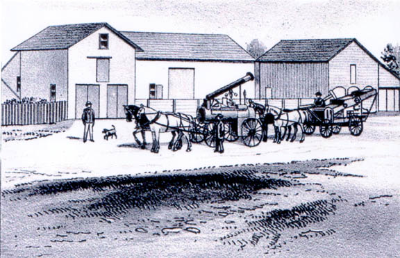
Lithograph depicting the barn and steam engine owned by William Garland.
(1877
History of Monroe County)
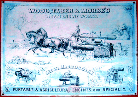
Tin sign advertising the steam engine works of Wood, Taber, & Morse.
(Author's
Collection)
Following the deaths of his grandsons, George and Edward Garland, the farm house on the opposite side of Clover Street, was unoccupied for many years and in the early 1970's was demolished and replaced by a new house. The large barn on the east side of Clover Street was included in the park land purchase and today is used by the Monroe County Sheriffs Department as a stable for its mounted horse patrol.
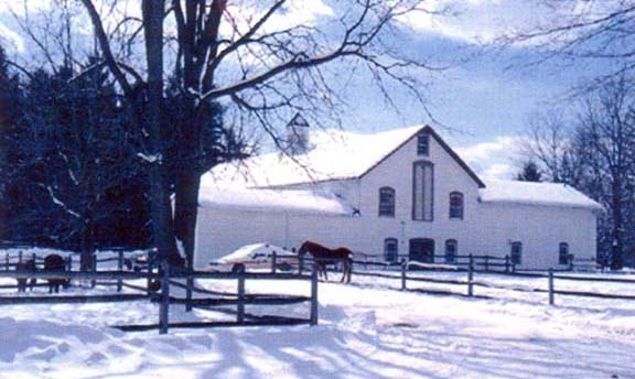
The Garland barn following restoration for use by the Mounted Patrol of
the
Monroe County Sheriff's Department. (Courtesy of Bea Brunstetter)
* * * *
Several years ago an anonymous donor approached the Monroe County Parks Department
with a proposal to built a sensory garden, specifically designed for people
who are blind or visually impaired. The garden, with seventy five different
plant varieties, is located next to the Nature Center in the Park. Signs in
braille, as well as English, describe many of the different plants located
at wheelchair height for the physically disabled to smell and touch.
In January 2006 Wild Wings, a not-for-profit educational organization that houses and cares for permanently injured, non-releasable birds of prey (raptors), opened a facility in Mendon Ponds Park. The facility is staffed by volunteers who care for the birds and conduct demonstrations using the raptors as partners in teaching environmental stewardship at schools, scout meetings, and many corporate and private events. At the present time the public may view eleven raptors and one bob cat in their spacious, well maintained cages.
In 1969 Mendon Ponds Park was named a National Landmark by an act of Congress because of its unique geological deposits: eskers, esker fans, and kettle holes. On October 2nd of that year a representative of the National Park Service formally presented Monroe County officials its registered landmark plaque. Also, presented at the ceremony was a certificate with the seal of the Department of Interior reading: "Mendon Ponds Park is hereby designated a Registered Natural Landmark under the provisions of the Historic Sites Act of August 21, 1935. This site possesses exceptional value in illustrating the natural history of the United States."
Sources of Information
Honeoye Falls Times, Rochester Democrat & Chronicle, Monroe County Departments
of Parks, Honeoye Falls/Mendon Historical Society, 1877 History of Monroe County,
1902 Plat Map of Monroe County, 1895 Landmarks of Monroe County, Rochester
Historical Society, Wild Wings Inc.
|