|
Mysterious Ruin at Bluff Point
by
There is no trace above ground today of the elaborate, extensive, grid-patterned
ruin of the Celtic-like "village" that was once situated on Bluff Point
above Keuka Lake. The ruin is on Skyline Drive, about four miles south
of Keuka Park, New York, which is just off Route 54-A. On the Yates County
highway map, Keuka Park is marked "Site of Primitive Mound Indians." There
are two mounds on Skyline Drive, one quite close to the ruin site and
directly north of it.
Detailed reports of the ruin come principally from only three sources
that I can find: 1) The results of a geological survey made of Yates County,
New York, in 1880. 2) The results of an excavation of the site carried
out in 1938 and 1939. 3) A brief report of the appearance of the site
in 1954.
The geological survey was made by Dr. Samuel
Hart Wright, MD, who also held an MA degree from Williams College,
was a land surveyor, and an internationally recognized biologist. He was
assisted by his son, Berlin Hart Wright, MD.
One of the first owners of the land, Howland Hemphill, who lived on the
site for 50 years, is mentioned by Berlin Hart Wright: "Mr. Hemphill was
an aged man at the time of our survey. He said he came to the farm as
a young man when the Indians were all about. In answer to a question...he
was informed that. ..(the ruin)... was there when the earliest tribesman
came to the region."
The 1938-1939 excavation by many persons was carried out under the direction
of a newspaper reporter from Canandaigua, New York, Mr. Gilbert T. Brewer.
The general appearance of the site did not seem to have changed much
from 1880 until as recently as 1954 when the author A. Glenn Rogers visited
there and wrote a brief account of it. I am sorry to report that by 1985,
and probably a decade or two earlier, the above ground remnants of the
site had been almost completely obliterated by vineyards, drainage ditches,
hay fields, farm work roads and a pine plantation. Inside the pine plantation
are two or three shallow depressions with several mounds of earth next
to them, probably all the remains of the 1938-1939 excavation.
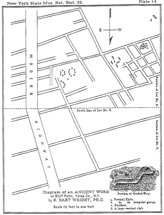
The schematic ground plan of the site made from the 1880 land survey
covers 13 acres of the ruin. The ruin was usually described as being between
14 and 20 acres in extent. The plan shows seven principal walls running
roughly NW - SE, one short wall running N - S, and 12 principal walls
running roughly NE - SW.
At the time the survey was made, Dr. Wright reports that the land in
Lot 5 (the northern five acres) shown on the plan had been plowed, and
some detail there was surmised by the Wrights from surface rocks. The
southern eight acres (in Lot 6) had never been plowed, was unforested,
and much detail was visible, as is obvious from the plan and from written
reports.
Among other things, the 1880s plan shows ten "rooms" that, had they been
roofed over, might have been dwellings or storage rooms, generally about
30 x 40 feet or slightly larger. There are also four still larger "rooms"
that might have been enclosures, for what, is unknown, and two enclosed
areas that might have been for ceremonial purposes. One of the latter
might have been a large antechamber. The other seems to have enclosed
two stone circles each with a diameter of about 30 feet, and a segment
of a third circle of similar size. Most of the rest of the ruin seems
to have consisted of walls which might have enclosed fields. Except for
their size and regularity, the "fields" are not unlike prehistoric and
medieval farming fields, consisting of long, relatively narrow strips
separated by stone walls. English archeologists call such fields "Celtic
Fields." No one had reported burials in connection with the site.
An account written by Berlin Hart Wright in 1880, or shortly thereafter,
states in part, "The remains of the ancient structure consisted of the
foundations of the walls, in the form of graded ways three to eight feet
wide and one to two feet high, bordered with a vast number of large, flat
stones set in the ground edgeways, these stones leaning inward toward
the center of the ways. At points of intersection of some of the walls,
depressions indicated posts had been standing there at one time, evidently
supporting a roof."
Dr. Wright's account published in the 1884 Thirty Fifth Annual Report
of the New York State Museum of Natural History, by the Regents of
the University, pages 193 and 194 states: "All the areas between these
ways are depressions, in which water remains until evaporated, the nearness
of the rock below, often being only twelve or fourteen inches, prevented
its absorption. These areas, or many of them, contain bogs of carex, and
some grass, but in the summer are dry and afford a fair pasturage. The
dirt used to make the ways was taken from these areas causing the depressions,
and the rock beneath was no doubt at that time completely laid bare and
furnished the flat stones that are set in on each side of the graded ways..
.No trees are in the structure exept a few young ones."
A. Glenn Rogers in his book Forgotten Stories of The Finger Lakes,
published in 1954, gives a description of what he saw of the stone and
earth works at the Bluff Point Site in 1954: "...these queer stone formations
are still clearly outlined. The ruins are comprised of well-arranged stone
floors and slab hedgerows. The stones dividing the sections are well cut,
resembling small slabs, and are placed in the ground at an angle, not
upright... The construction of a parallel ridge of stones is most peculiar.
They are raised 12 to 18 inches above the surface, and faced along the
sides with flat stones."
In the 1960s when telephone lines were buried along Skyline Drive, the
telephone company's ditching machine exposed one of the walls. The landowner's
description of the obstruction tallies exactly with the "graded ways"
described by Rogers and the Wrights.
Before going further, I would like to add that the description by the
Wrights and A. Glenn Rogers depicts all that is usually left today of
one type of ancient European dwelling. I have seen dozens of ancient wall
bases in the English Lake District that coincide with the Wright-Rogers
descriptions above, except that they are circular and are narrower. A
good sketch of the foundation of an intact dwelling may be seen in T.
Clare's Archeological sites of the Lake District (published in
1981). On page 21 he mentions "...the circular hut, although rectangular
buildings can also be present." and further states these foundation walls
"...do not belong to a single period but are found from the Bronze Age
to the post Roman period."
There are only two drawings of other sites that I can find that look
somewhat similar to the wall plan shown of the Bluff Point Site, although
neither shows such an elaborate site. Both drawings are on Page 68 of
The Druids by Stuart Piggott, published in 1968. One is labeled
"Angular ditched enclosures and graves, late pre-Roman, at Wallertheim,
Rheinhessen:" And the other as being ".. .of the Roman period against
the Roman road at Bokerly Dyke, Hampshire." Other illustrations in the
book make it apparent that Celts made much use of square and rectangular
structures involving earth banks and ditches.
Mr. David B. Kelley's Pre-Colonial Earthen & Stone Ruins in Yates
County, New York dated March 12, 1981, and updated on January 1,
1988, shows that there was a determined effort made in 1938 and 1939 by
Canandaigua, New York, newspaper reporter, Gilbert T. Brewer and several
others to excavate the site.
They found: "Bedrock quarried to a depth of 10 feet; arches were of sandstone,
the bases of which were set into the cut bedrock; stones engraved with
human and animal heads, along with iron objects with similar ornamentation;
one iron object with 'granular' ornamentation and another with a red enamel
design; broken metal platter; a metal detector indicated the presence
of stoneware including hammers, pounders, polishers, mortars and pestles,
and fragments of a 'seal'; among the images of humans, that of a woman
was the most frequent." Mr. Brewer is said to have thought "that the engraved
stone images were similar to the images found in paintings in Etruscan
tombs. He also thought that the iron implements were similar to those
known to be of Nordic origin."
Some, not all, of the artifacts found during the 1938 - 1939 excavation
certainly appear to have been of European origin. But the "Gil. Brewer
Collection" seems to have dropped out of sight. An article in a St. Petersburg,
Florida, newspaper in 1952 refers to him as "the late Mr. Brewer," and
I can find no indication of his movements, or his collection, after October
15, 1939.
What Was The Purpose and Who Built
The Mysterious Walls At Bluff Point?
The Ohio Mound Builders ("Hopewell" for short in this article) probably
cannot be ruled out at this point as possible builders of the walls. They
are not known, however, for the construction methods used at the Bluff
Point site. But neither is anybody else, in so far as I am aware, except
Bronze Age through post Roman Europeans. And I was told by New York State
archeologists, when trying unsuccessfully to interest them in the Bluff
Point site several years ago, that all the Hopewell groups known to have
been in this area were considered to be too primitive or too far regressed
to have accomplished any complex construction project.
The site is listed in what archeologists describe as their "bible," known
in short as "Parker - 1922." On page 717 is item 13: "Graded ways have
been described...on Lots 5 and 6, Bluff Point...Further reference is contained
in the twenty-fifth report of the Regents (p. 193)." (There is a detailed
reference in the Thirty-fifth report, starting on page 193, see above.)
The 193 -1939 excavation was apparently carried out without the help of
NYS archeologists, and its results do not seem to have been accepted by
them.
But some people similar to advanced Hopewell people were very active
in the area, and erected many very large, strange and wonderful earth/stone
works, which are also listed in "Parker -1922." See pages 716 and 717:
Items 1, 3, 10, 12, and 14. All the generally known large earth stone
works in Yates County have been destroyed, most since 1920, and at least
one was used for fill dirt by a highway department, one town highway supervisor
told me. Another local resident told me the boulders in the stone fort
on Bare Hill were used for roadbed.
Mr. David B. Kelley makes the suggestion in the last page of his updated
pamphlet that the ruin may have been intended as an observatory of astronomical
events. NE - SW and NW - SE alignments (but not walls in so far as I know)
are typical of prehistoric European sighting lines to such things as the
rising and setting sun on the solstices and equinoxes and on the days
half way in between. The latter, the "Cross Quarter Days," were of particular
interest to the Celts, as the Roman conquerors discovered.
The early Christian Bishops very wisely adopted the four Cross Quarter
Days of the Celts as Christian holy days. Three are now celebrated principally
in Ireland. The bishops slightly displaced the fourth day, Samhain, to
November first, and we call it "All Saints Day." Samhain was the Celts'
most important holy day. Halloween is also a remnant of Samhain.
But presumably the method of determining the date of Easter Sunday each
year was too firmly entrenched in the Christian world to permit moving
it to a specific Sunday from the traditional "first Sunday after the first
full moon after the spring equinox."
The Bluff Point Site would have made a good observatory as there is no
higher ground anywhere around, and vegetation was probably scarce due
to bedrock being so close to the surface.
It seems certain at this time that only a carefully controlled excavation
of the Bluff Point Site has a chance of settling the matter of who built
the site and what it was.
The owner of the Bluff Point Site stated several years ago that he would
like to see a proper excavation undertaken.
Authors's Note
Mrs. Virginia Gibbs, Yates County Historian, provided much of the information
used in this article. She has a few copies of the David B. Kelley typescript
mentioned above. This article would have been impossible to write without
the material contained in his paper; many of the quotes given here were
located by Mr. Kelley. A $5 check made out to "Yates County Historian"
to cover the cost of copying and mailing the typescript should accompany
a request sent to Mrs. Gibbs, 110 Court Street, Penn Yan, N.Y. 14527,
phone, 315-536-8748.
References
Clare, T., Archeological Sites of the Lake District
(1981) Moorland Publishing Company, Ashbourne, Derbyshire, U. K. DE6 1DZ.
Kelley, David B., Pre-Colonial Earthen & Stone Ruins
in Yates County, New York (1988) Typscript, privately printed.
New York State Museum of Natural History, 35th Annual
Report (1884).
Parker, Arthur C., The Archeology of New York.
NYS Museum Bulletin 237/238 Part 2 Albany, NY (1922).
Piggott, Stuart, The Druids (1975) Thames and
Hudson Inc. 500 Fifth Avenue, New York, N. Y. 10110.
Rogers, A. Glenn, Forgotten Stories of the Finger
Lakes (1954).
Yates County Chronicle (June 10, 1880).
|